Main rivers of Tatarstan: brief description, photo
The Republic of Tatarstan is distinguished by a largenumber of rivers. If you consider everything, even the smallest, then their number reaches about three thousand. The type of food is mostly mixed. In the spring of the Republic of Tatarstan, rivers often leave their channel, flooding nearby territories. But in summer and autumn there is a significant decrease in the water level. However, in particularly rainy years there are short-term floods. In the winter season, the rivers are covered with ice, as a rule, this happens in early November.
The main large rivers of Tatarstan are the Volga and the Kama. Also, their tributaries play an equally important role for the entire region.
Volga
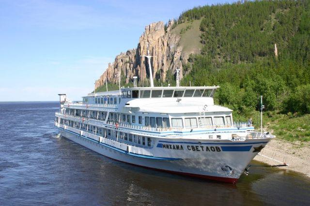
The largest and deepest river in Tatarstanis considered to be the Volga. Its length on the territory of the republic totals 177 km. The Volga is one of the few large rivers in the world that does not flow into the ocean. It has at least 300 tributaries, the largest and most important of which are the Oka and Kama. The source of the river is located on the territory of the Valdai Upland, and the mouth is the Caspian Sea. The watercourse takes its beginning from a small spring up to 1 m long and 30 cm deep, which is located among marshy lakes. Delta takes about 500 sleeves, its width is more than 30 km. The river flows into the Volga for 85 km. Kama, which makes the lower part of the channel very wide. These rivers of Tatarstan are the most important for the region. They are used not only in industry, but also in the tourism sector - there are organized walks on motor ships, in the coastal zones there are numerous recreation centers. On the Volga there are 8 main hydropower stations, which provide energy to the Volga region and industrial enterprises.

Kama
Kama is the most full river of the republicTatarstan. It is believed that it flows into the Volga, but there is much debate about this. Some scientists argue that the Kama channel was formed earlier. The source of the river is in the region of the Verkhnekamsk Upland. It starts with 4 small streams. In the Kama falls a huge number of rivers, the main of which are Vishera, Vyatka and Kelma. In its deep valley is located Nizhnekamsk reservoir. It is thanks to him that there is an energy supply to a significant part of the Volga region.
On the territory of Tatarstan, the river flows into theKuibyshev reservoir. In this place, Tanaevskie meadows were formed, which are part of the national protected park. In addition, Kama, like many other rivers of Tatarstan, is navigable. It is recognized as a major transport hub of Russia. The nature and landscapes of the coastal area attract relatively a relatively large number of tourists. Very often you can meet fishermen who come here for a catch.

Vyatka
Vyatka takes the leading position in the rating"The largest rivers of Tatarstan." It is the right tributary of the river. Kama. In the northern part of Udmurtia, the Yarskiy district is the source of the river, which flows from the Verkhnekamsk Upland. Its channel passes in the region of the Tatar city of Mamadysh. It is here that Vyatka flows into the Kama. It is interesting that these rivers start in the same elevation, after which several kilometers run in one direction, almost in parallel, until they turn in different directions: Vyatka - to the west, and Kama - to the east.
The most important tributaries of the river are the Cobra andMaloma (right), Kil'mez and Chapts (left). The current of Vyatka is marked by sharp changes in direction, the channel is meandering along the entire length. The river is a floating river, almost all along its length there is a constant navigable traffic.
White
The White River is the most beautiful and beautiful waterstream of Tatarstan. It is considered the largest left tributary of the Kama. Very often the names of the rivers of Tatarstan can be heard in the native language of local residents. That's why White is also referred to as Agidel.
In Bashkortostan, not far from Iremel, is its source. It is located in a marshy area and comes out at the foot of the Avalak mountains. The total length of this river is over 1,400 km. For the White is characterized by rapid flow, sharp slopes, steep turns, inhomogeneity of the coastline. In a word, the nature of this watercourse is quite steep. However, when r. Ufa, then the turbulent current turns into a more calm and measured, which is typical of the flat rivers. The main tributaries can be considered Ufa, Sim, Nugush, Bir. The White River is very popular among fishermen and tourists.
Sviyaga